NAV CANADA, the country's provider of civil air navigation services, conducted an aeronautical study that reviewed the requirements for the provision of Air Traffic Services and airspace in the vicinity of Nanaimo.
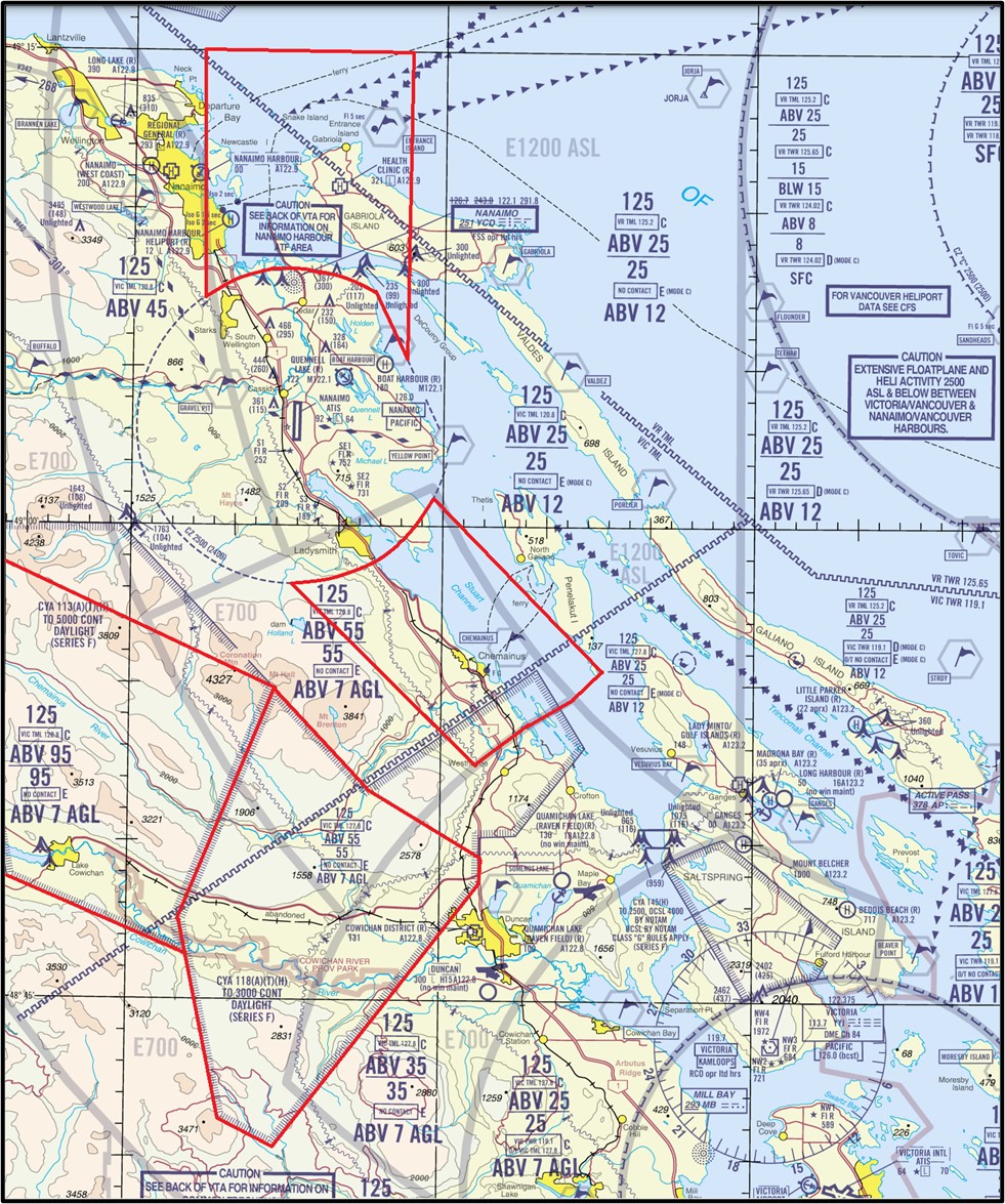
The study recommended changes be made to airspace in the vicinity of Nanaimo and the creation of a 5 NM Mandatory Frequency (MF) area to 1,200 feet ASL centred on Nanaimo Harbour Water Aerodrome (CAC8) excluding the Nanaimo Control Zone.
The new Nanaimo Harbour MF will also include the following locations within 5 NM:
The airspace changes include:
The modified airspace in the vicinity of Nanaimo will be appear in the Designated Airspace Handbook (TP 1820E) as follows:
3.1.1 TRANSITION AREAS
3.1.1-47 Vancouver, BC:
3.1.1-50 c) The airspace above 700´ AGL within the area bounded by a line beginning at:
N48°47'32.39" W123°49'18.43" thence clockwise along the arc of a circle of
35 miles radius centred on
N49°11'42.00" W123°10'55.00" (Vancouver Intl, BC - AD) \ to
N48°57'01.19" W123°59'13.76" to
N49°01'15.10" W123°45'27.84" thence counter-clockwise along the arc of a circle of
25 miles radius centred on
N49°11'42.00" W123°10'55.00" (Vancouver Intl, BC - AD) \ to
N49°00'26.25" W123°44'50.09" to
N48°55'28.39" W123°37'10.29" to
N48°54'35.83" W123°38'35.92" thence counter-clockwise along the arc of a circle of
18 miles radius centred on
N48°38'49.30" W123°25'32.80" (Victoria Intl, BC - AD) \ to
N48°47'32.39" W123°49'18.43" point of beginning
3.1.1-51 d) The airspace above 700´ AGL within the area bounded by a line beginning at:
N49°15'00.00" W123°47'38.27" to
N49°06'30.82" W123°47'38.27" to
N49°07'25.23" W123°48'17.55" thence counter-clockwise along the arc of a circle of
5 miles radius centred on
N49°03'08.00" W123°52'13.00" (Nanaimo, BC - AD) \ to
N49°07'07.90" W123°56'47.73" to
N49°15'00.00" W123°56'47.73" to
N49°15'00.00" W123°47'38.27" point of beginning
3.1.3 TERMINAL CONTROL AREAS
3.1.3-8 Vancouver, BC TCA:
3.1.3-12 d) Class C airspace above 2500´ to 4500´ within the area bounded by a line beginning at:
N48°17'02.50" W123°14'54.40" Can/USA bdry \ to
N48°20'53.13" W123°26'34.07" thence clockwise along the arc of a circle of
5 miles radius centred on
N48°25'22.00" W123°23'15.00" (Victoria Harbour, BC - AD) \ to
N48°22'19.13" W123°29'11.73" to
N48°26'24.52" W123°33'56.16" to
N48°27'33.05" W123°31'42.78" to
N48°32'14.86" W123°29'08.95" thence clockwise along the arc of a circle of
7 miles radius centred on
N48°38'49.30" W123°25'32.80" (Victoria Intl, BC - AD) \ to
N48°45'45.19" W123°24'07.78" to
N48°48'09.82" W123°23'38.13" thence clockwise along the arc of a circle of
25 miles radius centred on
N49°11'42.00" W123°10'55.00" (Vancouver Intl, BC - AD) \ to
N48°54'35.83" W123°38'35.92" thence counter-clockwise along the arc of a circle of
18 miles radius centred on
N48°38'49.30" W123°25'32.80" (Victoria Intl, BC - AD) \ to
N48°52'26.22" W123°43'18.04" to
N48°58'08.27" W123°52'06.73" thence counter-clockwise along the arc of a circle of
5 miles radius centred on
N49°03'08.00" W123°52'13.00" (Nanaimo, BC - AD) \ to
N49°00'50.62" W123°45'27.81" to
N49°00'25.21" W123°44'48.48" thence clockwise along the arc of a circle of
25 miles radius centred on
N49°11'42.00" W123°10'55.00" (Vancouver Intl, BC - AD) \ to
N49°01'15.10" W123°45'27.84" to
N48°59'08.26" W123°52'21.39" thence clockwise along the arc of a circle of
30 miles radius centred on
N49°11'42.00" W123°10'55.00" (Vancouver Intl, BC - AD) \ to
N49°07'26.18" W123°56'05.52" thence counter-clockwise along the arc of a circle of
5 miles radius centred on
N49°03'08.00" W123°52'13.00" (Nanaimo, BC - AD) \ to
N49°07'07.90" W123°56'47.73" to
N49°11'38.84" W123°56'47.73" to
N49°18'12.62" W124°03'22.44" thence clockwise along the arc of a circle of
35 miles radius centred on
N49°11'42.00" W123°10'55.00" (Vancouver Intl, BC - AD) \ to
N49°34'27.22" W123°51'33.51" to
N49°20'10.74" W123°25'56.37" thence clockwise along the arc of a circle of
13 miles radius centred on
N49°11'42.00" W123°10'55.00" (Vancouver Intl, BC - AD) \ to
N49°23'53.71" W123°17'43.39" to
N49°20'08.72" W123°15'37.38" to
N49°20'04.85" W123°03'25.40" to
N49°18'50.01" W123°01'44.09" to
N49°15'16.31" W123°01'44.14" to
N49°15'17.00" W122°45'30.28" thence clockwise along the arc of a circle of
3 miles radius centred on
N49°12'58.00" W122°42'36.00" (Pitt Meadows, BC - AD) \ to
N49°14'11.84" W122°38'25.62" to
N49°07'16.72" W122°33'41.11" thence clockwise along the arc of a circle of
3 miles radius centred on
N49°06'03.00" W122°37'51.00" (Langley Regional, BC - AD) \ to
N49°06'02.91" W122°33'17.10" to
N49°00'07.92" W122°33'17.10" Can/USA bdry \ thence west along the Can/USA bdry \ to
N48°17'02.50" W123°14'54.40" Can/USA bdry \ the point of beginning
Note: The Vancouver TCA also contains that portion of airspace, south of the
CAN/USA boundary, within 16NM of the Vancouver VOR that is defined in
U.S. publications.
3.1.3-13 e) Class C airspace above 1200´ to 2500´ within the area bounded by a line beginning at:
N49°15'00.00" W123°47'38.27" to
N49°06'30.82" W123°47'38.27" to
N49°07'25.23" W123°48'17.55" thence counter-clockwise along the arc of a circle of
5 miles radius centred on
N49°03'08.00" W123°52'13.00" (Nanaimo, BC - AD) \ to
N49°07'07.90" W123°56'47.73" to
N49°15'00.00" W123°56'47.73" to
N49°15'00.00" W123°47'38.27" point of beginning
3.1.3-14 f) Class C airspace above 1500´ to 2500´ within the area bounded by a line beginning at:
N49°00'50.62" W123°45'27.81" to
N48°55'28.39" W123°37'10.29" to
N48°54'35.83" W123°38'35.92" thence counter-clockwise along the arc of a circle of
18 miles radius centred on
N48°38'49.30" W123°25'32.80" (Victoria Intl, BC - AD) \ to
N48°52'26.22" W123°43'18.04" to
N48°58'08.27" W123°52'06.73" thence counter-clockwise along the arc of a circle of
5 miles radius centred on
N49°03'08.00" W123°52'13.00" (Nanaimo, BC - AD) \ to
N49°00'50.62" W123°45'27.81" point of beginning
3.1.3-15 g) Class C airspace above 4500´ to 5500´ within the area bounded by a line beginning at:
N48°54'35.83" W123°38'35.92" thence counter-clockwise along the arc of a circle of
18 miles radius centred on
N48°38'49.30" W123°25'32.80" (Victoria Intl, BC - AD) \ to
N48°52'26.22" W123°43'18.04" to
N48°58'08.27" W123°52'06.73" thence counter-clockwise along the arc of a circle of
5 miles radius centred on
N49°03'08.00" W123°52'13.00" (Nanaimo, BC - AD) \ to
N49°00'50.62" W123°45'27.81" to
N49°00'25.21" W123°44'48.48" thence counter-clockwise along the arc of a circle of
25 miles radius centred on
N49°11'42.00" W123°10'55.00" (Vancouver Intl, BC - AD) \ to
N48°54'35.83" W123°38'35.92" point of beginning
5.3 ADVISORY AREAS
CYA113(A)(T)(H) NANAIMO, BC
The airspace within the area bounded by a line beginning at:
N48°48'46.00" W124°05'43.00" to
N48°59'59.00" W124°09'05.00" to
N48°54'52.14" W123°53'03.92" to
N48°47'31.07" W123°57'32.72" to
N48°46'26.69" W123°57'11.90" to
N48°48'46.00" W124°05'43.00" point of beginning
Designated Altitude – Surface to 5000´
Time of Designation – Cont daylight
Operating Procedures – The rules for Class G airspace apply when the area is active. When not
active, the rules for the applicable surrounding airspace apply.
CYA118(A)(T)(H) DUNCAN, BC
The airspace within the area bounded by a line beginning at:
N48°41'14.00" W123°55'31.00" to
N48°47'31.07" W123°57'32.72" to
N48°54'52.14" W123°53'03.92" to
N48°51'43.46" W123°48'31.34" to
N48°49'27.53" W123°43'05.21" to
N48°48'44.90" W123°43'05.66" to
N48°40'21.00" W123°52'54.00" to
N48°41'14.00" W123°55'31.00" point of beginning
Designated Altitude – Surface to 3000´
Time of Designation – Cont daylight
Operating Procedures – The rules for Class G airspace apply when the area is active. When not
active, the rules for the applicable surrounding airspace apply.
NOT FOR NAVIGATION
This change will take effect on 17 April 2025 at 0901Z Coordinated Universal Time (UTC).
The appropriate aeronautical publications will be amended.